Several more maps are discussed in this article. I figure there has to be at least one other forum member who enjoys looking at old maps.Back when mapmaking was still a fledgling profession in the U.S., cartographers had a trick up their sleeves: they would insert fake towns into the maps they drew. ... if a fake town was spotted in a competitor's map, it was easy to prove copyright infringement.
The first fake town to appear was Agloe, New York, which appeared in the 1930s on a map by the General Drafting Co. It then reappeared on maps produced by Rand McNally when mapmakers for the company found someone had started a business at the exact spot of the fictitious Agloe and named it the Agloe General Store—thereby making the town “real.”
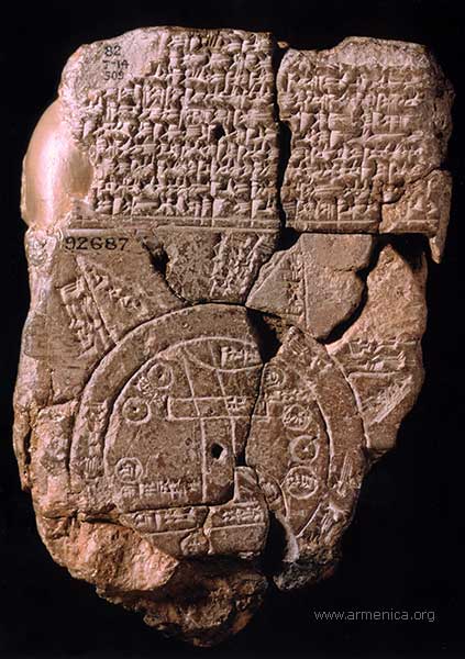
. . . The oldest known maps began to appear in about 2,300 B.C.E., carved into stone tablets. We’re not sure if any fake towns appear on the maps below, but here are six of the world's oldest or first of their kind that you can go see today.
More commonly known as the Babylonian Map of the World, the Imago Mundi is considered the oldest surviving world map. It is currently on display at the British Museum in London. It dates back to between 700 and 500 BC .... The carved map depicts Babylon in the center; nearby are places like Assyria and Elam, all surrounded by a “Salt Sea” forming a ring around the cities. ... The map is accompanied by a cuneiform text describing Babylonian mythology in the regions depicted on the stone.
This 1502 map, created by an unknown Portuguese mapmaker in Lisbon, was once the subject of international espionage. It’s named after Alberto Cantino, an Italian who was an undercover spy for the Duke of Ferrara. ... the important thing about this map is ... that ... it included several firsts for maps at the time: it was the first in history to include the Arctic Circle, the equator, the tropics, and the border between Portuguese and Spanish territories. It also has the first named depiction of the Antilles and potentially the first image of Florida’s lower coastline. The Planisphere {is} on display in the Galleria Estense in Italy.
Where to See Some of the World’s Oldest and Most Interesting Maps
-
de officiis

- Posts: 2528
- Joined: Wed Nov 30, 2016 11:09 am
Where to See Some of the World’s Oldest and Most Interesting Maps
[url=ttp://www.smithsonianmag.com/travel/where-see ... dPTXxH5.99]Where to See Some of the World’s Oldest and Most Interesting Maps[/url]


-
Okeefenokee
- Posts: 12950
- Joined: Wed Nov 30, 2016 10:27 pm
- Location: The Great Place
Re: Where to See Some of the World’s Oldest and Most Interesting Maps
What are you're thoughts on big ass globes?
I'm for 'em.
p.s. your link's messed up
http://www.smithsonianmag.com/travel/wh ... 180963855/
I'm for 'em.
p.s. your link's messed up
http://www.smithsonianmag.com/travel/wh ... 180963855/
GrumpyCatFace wrote:Dumb slut partied too hard and woke up in a weird house. Ran out the door, weeping for her failed life choices, concerned townsfolk notes her appearance and alerted the fuzz.
viewtopic.php?p=60751#p60751
-
Fife

- Posts: 15157
- Joined: Wed Nov 30, 2016 9:47 am
Re: Where to See Some of the World’s Oldest and Most Interesting Maps
Make it yourself, like a good chap, will you? The bar's in the globe.Okeefenokee wrote:What are you're thoughts on big ass globes?
I'm for 'em.
-
de officiis
- Posts: 2528
- Joined: Wed Nov 30, 2016 11:09 am
Re: Where to See Some of the World’s Oldest and Most Interesting Maps
We had a decent globe around here when the kids were little, not sure what my daughter did with it. I think it would be fun to have a furniture-sized globe somewhere in the house, but acquiring things like that in the last few years has been problematic since my spouse has been in a default "less is better" mode.
Raven Maps has some cool maps. I had their big map of the US for a long time before donating it to my kids' elementary school.
Raven Maps has some cool maps. I had their big map of the US for a long time before donating it to my kids' elementary school.